Submitted by Rachel Gardner on Tue, 07/03/2023 - 11:41
Researchers have developed an algorithm that uses computer vision techniques to accurately measure trees almost five times faster than traditional, manual methods.
The researchers - PhD student Amelia Holcomb and her supervisor Prof Srinivasan Keshav, along with Linzhe Tong at the University of Waterloo - developed the algorithm, which gives an accurate measurement of tree diameter, an important measurement used by scientists to monitor forest health and levels of carbon sequestration.
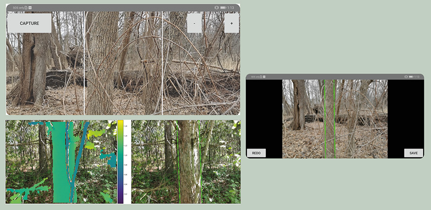
The algorithm uses low-cost, low-resolution LiDAR sensors that are incorporated into many mobile phones, and provides results that are just as accurate, but much faster, than manual measurement techniques. The results are reported in the journal 'Remote Sensing'.
The primary manual measurement used in forest ecology is tree diameter at chest height. These measurements are used to make determinations about the health of trees and the wider forest ecosystem, as well as how much carbon is being sequestered.
 While this method is reliable, since the measurements are taken from the ground, tree by tree, the method is time-consuming. In addition, human error can lead to variations in measurements.
"When you're trying to figure out how much carbon a forest is sequestering, these ground-based measurements are hugely valuable, but also time-consuming," said first author Amelia Holcomb (pictured right), a PhD student and Harding Distinguished Postgraduate Scholar here. "We wanted to know whether we could automate this process."
Some aspects of forest measurement can be carried out using expensive special-purpose LiDAR sensors, but Amelia and her colleagues wanted to determine whether these measurements could be taken using cheaper, lower-resolution sensors, of the type that are used in some mobile phones for augmented reality applications.
This line of research is something Amelia feels very strongly about.
"Throughout my undergraduate degree and subsequent jobs in tech, I felt a disconnect between the topics in math and computer science that were most intellectually exciting to me and the social issues I was most passionate about," she explains.
"Around four years ago, a friend brought me to a panel discussion on the climate crisis between Kate Marvel, a physicist, Rhianna Gunn-Wright, a co-author of the Green New Deal, and Ayanna Elizabeth Johnson, a marine biologist and policy advocate. These women convinced me that social, environmental, and technical problems are deeply intertwined and empowered me to turn my skills toward addressing them.
"I left my job the following summer and started a master's degree with one of my current supervisors, Srinivasan Keshav, whose work focuses on using computer science tools to protect the environment and reduce carbon emissions. This paper on tree measurement grew out of that master's thesis.
"Since then, I have become interested in remote sensing of forest degradation and recovery, and more broadly in the use of satellite remote sensing to assess global environmental change and guide policy decisions."
She adds: "I think there is an incredible opportunity to bring computer science to bear on this problem, because these complex sensors and large datasets require the development of novel techniques in distributed geospatial computing, image processing, and statistical modeling.
"I was honored to be selected as a Harding Scholar at Cambridge to pursue my PhD in this area. The Harding funding has allowed me to take on interdisciplinary research co-supervised between computer science and plant sciences, using computer science to address real-world environmental problems.
"Sitting in the audience four years ago at that panel, I could not have imagined that today I would be here."
- Read the full story - 'Phone-based measurements provide fast, accurate information about the health of forests' - on the University of Cambridge website.